Printable Map of the United States
Choose labels and colors, then print a US map of all 50 states on Letter or A4, or download it as PNG or SVG.
Recent
Your last 10 settings, saved only in this browser. Nothing is uploaded.
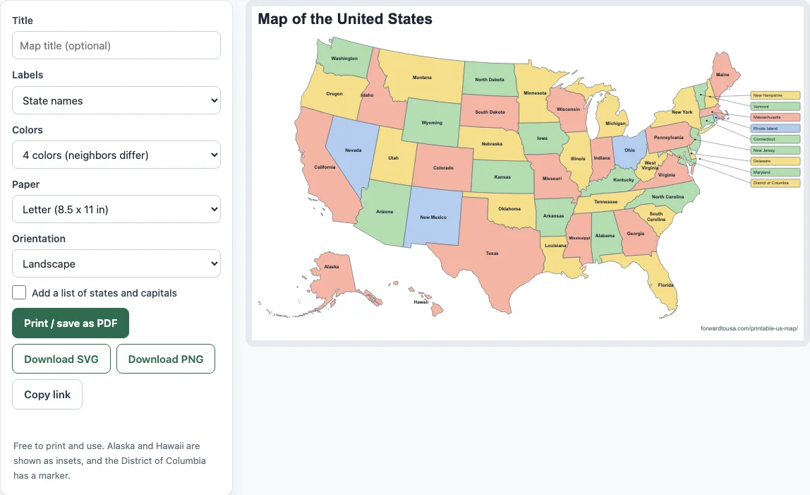
This free printable map of the United States shows all 50 states and the District of Columbia on Letter or A4 paper. You choose the labels and colors, then print the map or save it as a PDF. It runs in your browser with no sign-up, and nothing you type is sent anywhere. Alaska and Hawaii appear as insets, and DC has a marker. Use it for a classroom handout, a worksheet, or a home project.
Every option is shown in the preview before you print, so you can try names, then capitals, and see which fits your page.
Nothing to install or download first.
How to use the Printable US Map
- Type a title in Title. Leave it blank to get “Map of the United States.”
- Pick a Labels option: None, Abbreviations, State names (the default), or State names + capitals.
- Pick a Colors option: 4 colors (the default), Light pastel, Grayscale, or Outline only.
- Pick a Paper size: Letter or A4.
- Pick an Orientation: Landscape or Portrait.
- Tick Add a list of states and capitals if you want a table of all 51 rows.
- Check the preview. It is exactly what prints and downloads.
- Click Print / save as PDF. In the print dialog, set margins to Default or None and scale to 100%.
To keep a file instead, use Download SVG for a vector file or Download PNG for an image. The PNG is about 3,200 px wide, roughly 300 dpi on 11 in. Copy link gives you a link that holds your current settings. Printed maps may be used for any purpose, including in products for sale, royalty-free and without credit. The only limit is that you may not copy the website or tool itself as a competing service.
The preview changes as you choose each option, and the page address keeps your choices, so “Copy link” opens the same map later.
Where can I print a map of the United States for free?
The tool is free to print and use, so you can make the map from your own browser at no cost. Set Labels and Colors to what you need, then select Print / save as PDF. The printout matches the preview, including the title and a small site address line at the bottom.
Can I get a US map with state names?
Yes. Labels set to State names is the default. Each state gets its name inside its outline. The nine smallest north-eastern units (NH, VT, MA, RI, CT, NJ, DE, MD and DC) are too small for text inside, so their labels sit in a column on the right and connect to their shapes with leader lines.
Can I get a US map with capitals?
Yes. Set Labels to State names + capitals. Each capital is printed in smaller type under the state name, at the state’s label point. The tool does not draw capital dots, because it has no verified coordinates for them. In the side column, boxes read like “Vermont · Montpelier.” For a full table, also tick Add a list of states and capitals.
How do I print only black and white?
Set Colors to Outline only for plain outlines with no fill. Set it to Grayscale if you want the states shaded in gray tones. Both options print cleanly on a black-and-white printer.
Why does each state have a different color?
The 4 colors scheme is a fixed assignment worked out from the outline shapes. No two states whose outlines touch share a color, so every border stands out on paper. Alaska, Hawaii and DC each have their own entry in the scheme.
Does it include Alaska and Hawaii?
Yes. Alaska and Hawaii are drawn as insets beside the lower 48, so they fit on the same sheet. They are not drawn to the same scale as the other states.
Letter or A4?
Both are available under Paper. Letter is 8.5 x 11 in (215.9 x 279.4 mm). A4 is 210 x 297 mm. Either way, the map sits inside 10 mm of padding.
What is the capital of DC?
The District of Columbia has no capital, because it is itself the seat of the federal government. On the map, DC reads “District of Columbia” with no capital. In the list, its row reads “None (federal district).”
Can I use the map for a class or a worksheet?
Yes. The map may be printed and shared freely, including in classrooms. Landscape suits labeled maps best. Portrait leaves room for the capitals list on the same page as the map. For a worksheet where students write in state names, choose Outline only.
Frequently asked questions
Can I use the printable US map for commercial purposes or sell printed copies?
Yes. Printed maps may be used for any purpose, including in products for sale, royalty-free and without credit. The only limit is that you may not copy the website or tool itself as a competing service.
Where do the state outlines come from?
They come from the US Census Bureau TIGERweb Generalized ACS 2025 dataset, fetched 2026-07-28. The map uses the Albers USA projection, with Alaska and Hawaii as insets that are not to scale.
What is the difference between the PNG and the SVG?
The SVG is a vector file, so it scales to any size without losing sharpness. The PNG is a fixed image rendered at 3.4 times the SVG size, about 3,200 px wide.
Why do my printed margins look wrong?
The sheet is sized in millimeters for the paper you picked, with 10 mm padding. If the print dialog adds margins or scales the page, the map may not fit. Set margins to Default or None and scale to 100%.
Does the tool keep what I type?
No. Everything runs in your browser, and nothing you type is sent anywhere. It is free with no sign-up.
Related tools
- States visited map: Use it to mark the states you have been to.
- Blank US map: Use it when you want an empty outline for your own labels.
- National parks map: Use it to plan visits to national parks on a map.
- National parks checklist: Use it to track which national parks you have visited.
- Travel itinerary template: Use it to lay out the days and stops of a trip.